Is The Sun Setting On Claygate's Green Belt?
Claygate's Green Belt faces an unholy alliance between big landowners, developers and the government. The government is proposing changes to planning rules that will remove Green Belt protections from vast areas of Green Belt.
The landowners will get a windfall gain from the revaluation of land previously categorised as countryside. The developers will win by being able to sell large numbers of new houses, hardly any of which will meet the normal definition of "affordable". And the government will take another contrived step towards its pledge to build 1.5 million new dwellings.
In Claygate, this means that areas including…
- Loseberry Farm to the west of Claygate
- Horringdon Farm to the southwest
- The land between the northern end of Oaken Lane and Littleworth Road to the north
- The old rugby ground to the north
- Most of Telegraph Hill, and
- The fields between Telegraph Hill and Surbiton Golf Club
…are now all open to development
The Facts
Your Questions About the Threat to Claygate's Green Belt answered.
WHY IS THE GREEN BELT SO IMPORTANT TO CLAYGATE?
WHY IS IT NOW UNDER THREAT?
WHAT HAS HAPPENED SO FAR?
AND THE THREAT TO CLAYGATE?
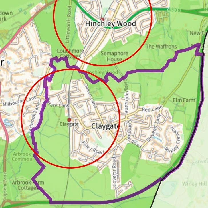
Areas 800m from the Station
This map shows areas (circled in red) considered "reasonable walking distance" from Claygate and Hinchley Wood stations. The Green Belt is shown in...er, green. It is likely developers would argue more than 1km still constitutes "reasonable walking distance", which would put approximately 258 Hectares of Claygate Green Belt under the threat of default development approval.